

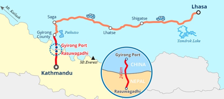
Gyirong Port
Gyirong Port is located in Gyirong County, southwest corner of Tibet Autonomous Region. Gyirong County belongs to the south side of the middle part of the Himalayas, some 831km away from Lhasa, 175km away from Katmandu. In history, it was the largest land trading port between Tibet and Nepal, also an important transportation hub of the cultural and business exchange between China and Southern Asia countries. Gyirong Port witnessed many historical events: Princess Bhrikuti of Nepal traveled a long journey to marry Songtsen Gampo; the famous diplomat Wang Xuance in the Tang Dynasty made several foreign visits to India; Indian Buddhist master Padmasambhava (Lotus-Born) entered Tibet to spread Buddhism. They all passed through Gyirong.
In the 1970s, Chinese government ranked Gyirong Port as National Second Level Land Port, attached with departments of customs and commodity inspection. Later on, due to the prosperity of Zhangmu Port, all export and import business through Gyirong Port have almost stopped and the relative departments were revoked. In the past, Yadong port, Zhangmu port, and Burang port are three major ports and business hubs in Tibet. Before the usage of Gyirong Port, Zhangmu port was the only land port that opened all year around in Tibet and it forced almost 90% of Tibet’s border business. But limited by geographical reasons, Zhangmu port’s clearance capacity is relatively weak, restricting the foreign trade development in Tibet. In April 2015, Zhangmu port was badly damaged because of Nepal earthquake and was temporarily closed. In December 2015, China Gyirong-Nepal Rasuwa bilateral port was put into formal use. Gyirong port becomes the bridgehead of Tibet’s opening to the world and a significant commercial road linked to Nepal and other Southern Asia countries.
Starting from Katmandu, going northward for about 175km, passing through Gyirong Port, you will reach Gyirong Valley, which is regarded as the “back garden of the Mt. Everest”. To continue going northwest for about 700km, there is the holy mountain of Buddhism, Mount Kailash; eastward for about 400km, there is the Mt. Everest. On southwest, Gyirong borders the Nepali city Pokhara, which is the most famous tourism spot in Nepal and is reckoned by worldwide visitors as a “Paradise of hiking”.
Nowadays, asphalt road has been constructed and open to traffic between Lhasa and Gyirong Port. Trucks from Chinese inland cities could go to Gyirong via Shigatse through Qinghai–Tibet Railway and Lhasa– Shigatse Railway, then passing through Gyirong Port to reach Katmandu. With the continuous improvement of infrastructures, transportation factor will not limit the development of Gyirong Port any more. It is estimated that after the railway between Lhasa and Gyirong is finished, it will further promote the exchange between China and the Southern Asia Continent.
Gyirong has always been a transitional zone of culture and economic exchange between Tibet and Southern Asia countries. Thanks to the establishment of nature reserves and constructions of roads and railways, the small town Gyirong is not just a simple courier station of cultural and economic exchange in history, but will be a pluralistic and radioactive transportation hub and international port, which presents an enormous business opportunity. It can be said that, through exploration and development, Gyirong, never fading charms in the past, will definitely become a shining superstar on the borderline of China.
Gyirong Valley
Gyirong Valley is at the southern foot of the central Himalayas. It stretches from north to south for over 100 kilometers, beginning at the Gyirong County and going all the way down to Gyirong Port, the China-Nepal border. With ridgelines on its both sides as its boundaries, the valley is 300 to 2000 meters in width and covers an area of about 2500 square kilometers. Because connections between Gyirong and Lhasa are hindered by Mount Marrah (altitude: 5770m) at the north of the valley, Gyirong Valley has become a relatively closed area where few people live and visit in history.
The altitude of Gyirong Valley is 1700 meters in the south before it is raised to about 7000 meters in the north. The difference in altitude in the valley plus the warm wet airflows coming from the Indian Ocean hitting the south slope of the Himalayas form a unique vertical ecosystem combination: in the south there’re ditches and rivers, in the central area there’re forests and in the north there’re snow mountains and glaciers. In just about 100 kilometers there’re all together six major ecosystems, forming a unique vertical landscape system.
The Himalayas sprawls from east to west, blocking the south-coming warm wet airflow from the Indian Ocean and making the climates of the north and south slopes very different. The north of Gyirong is a cold semi-arid plateau-valley monsoon climatic region with an annual average temperature of 2℃, the warmest month temperature of 10-18℃, the coldest month temperature of -10℃ and an annual precipitation of around 300-600 millimeters. It has a semi-arid continental climate. On the other hand, the south of Gyirong has a subtropical mountain region monsoon climate with an annual temperature of 10-13℃, the warmest month temperature of over 18℃, an annual precipitation of around 1000 millimeters and an annual number of frost-free days at above 200. Its winters are short and rainy and it doesn’t have four distinct seasons—it’s like spring all year round with flowers blossoming and it’s always warm and wet.
Gyirong Valley is an important part of the Himalayas National Natural Reserve and is the biggest area with the most beautiful ecological environment and the biggest variety of ecological species in the reserve. Key protective plants and animals in the Himalayas Natural Reserve are widely distributed in the area and some species only inhabit in this area, which makes the area one of the most important regions in the reserve. Therefore, Gyirong Valley is also called as “the back garden of the Himalayas”. Forests of picea smithiana, taxus wallichiana and pinus palustris grow in the area and there’re also many valuable and rare animals here, such as assamese macaque, himalayan tahr, semnpithecus entellus, moschus leucogaster, lophura leucomelana, himalayan goral, selenarctos thibetanus and blood pheasant.
Geologists have found palaeotherium orictocoenosis mainly features as Gyirong three-toed horse fossils in the western Gyirong County. The orictocoenosis includes over ten mammals like Gyirong three-toed horse, Tibetan chilotherium and Gyirong Ochotona. This relic implies that in pliocene epoch (30 million years before) the altitude of West Himalayas was between 500 to 1000 meters and Mount Everest was around 3000 meters in altitude. Climate was warm and wet and the places had natural landscapes like forests and grasslands. Since then, the Gyirong basin has risen by about 2500 to 3000 meters.
Places to see in Gyirong
Nitsun in Gyirong
“Nitsun” means “seat” in Tibetan, “the holy place blessed by divinities”, which cannot be called haphazardly as a village’s name. The terrain of the village is more featured as a royal throne. It is said that when Atiśa was invited to Tibet, he came from India to Nepal firstly, then went to Gyirong through Rasog, and lived in Nitsun for one year, Atiśa was enlightened and assigned as the host of this area. The story goes like this, when Atiśa looking from the above, he had his eyes on Nitsun, which is exactly a paradise, instead of being a human society. Though this is just a legend, it also illuminates how fascinating the landscape here is.
Located in the towering peak in the north of Gyirong Town, the village is a perfect choice to appreciate snow mountain, morning clouds, sunset and local folk customs. The Z-shaped hilly road, from the fascine dam at the foot of Simla Hills, travels 11 turns consecutively, then leads straightly to the cloud-covered hilltop. Villagers had to pass along the path up and down every day, winding through valley and forest, before the road was built in 2008. Those footpaths were the best way to hike in the village. It took always two to three hours uphill, while going downhill is more easily, taking just an hour. The hilly road stretches to the mountaintop, where there is a flat land for more than 10 km2. Two primitive villages, scatter at the western and eastern sides of the land, boast blue-green or white-red steel sheet roof, very eye-catching and orderly in this area, which is harmonious with distant snow mountain and forests. The two village, named as East Nitsun and West Nitsun, or Shang Nitsun and Xia Nitsun, is home to 68 families, almost some 400 villagers.
There are green farmlands planting barley and wheat in the neighboring, and rough roads sinuate across the fields. Outside the lands are grassplots, dotted with blossoming wild flowers and fluttering bees and butterflies. The southwestern greensward of the flatland is the fairyland for children playing. It is a green pastoral world, a heaven of peace. Pastures interlaced between these villages and fields, interspersed idle flocks and herds. When enjoying the rural idyllic scenery, the pure and hospitable villagers are willing to generously treat you with buttered tea, pancakes, home-made yogurt and barley wine in their homes.
Nitsun is the best spot to enjoy natural landscapes including icy peaks, sunrise and sunset because of its elevated land and wide vision. From this position and view, the snow mountains and glaciers seem more splendid and charming. The snow-capped Mt. Qumugula stands before your very eyes clearly across the western valley, snowy ridges stretch for miles and stone peaks stand in stalwart figure. Under a blue sky, Goddess Peak puts her hands together and sits up facing to the south, vividly and perfectly. In front of the snow hills, the thick-ink-saturated brush of Tiebi Peak points to the sky and sprinkling freely. The Snow Mount Rawobanba, lying in the northwest, with uneven peaks and sharp blades, looks like a huge white-jade screen looming over immense forests and peaks. In the northern stripes of land between mountains, the Purog Kangri glacier spans two peaks like a great wall.
It is noted that in the southeast of Nitsun, there is a stretching snowy peak across Mount Laduo which straightly pointing into the sky. It is Annapurna peaks and Lattice Rooney Peak, which can be appreciated in Pokhara, an outstanding tourism city of Nepal. Annapurna peaks, or Kutang Peak, has an altitude of 8,091 meters, ranked as the tenth highest peak on the earth. It is regarded as the hardest snow mount to climb in the world. To conquer it, the mountaineering community have paid a heavy price. While on the south of the Annapurna snow-capped mountains, there is Geluni Peak, which is 6,977 meters above sea level. Its peak is divided into two parts, just like a fishtail, so it is also called Fish Tail Peak. As one of the national signs in Nepal, it remains a bouncing silver fish end in the skyline.
The various and rapidly changing clouds make these majestic and lofty glaciers more fascinating. Sometimes, slight clouds haunt over the shiny snow mountains, neither friendly nor aloof. The outstanding and stalwart snow hills are manifested by the gentle clouds, while the forceful mountain also sets the elegant and tender clouds off to an advantage. The sunshine not only spreads warmth and bright to the lofty plateau but also bring heavenly and beautiful scenery to Gyirong. In the morning, the genial sunshine warms up the floating clouds and edges a golden halo for the eastern glaciers. The sun is unwilling to go down in the evening at eight or nine. Twilights shine upon clouds, wreathing the mountains, and sunset tints the snow mountains in spectacular glamor.
Jifu Canyon in Gyirong
Jifu Canyon is located at two kilometers southwest of Gyirong Town. The canyon is formed under the effect of strata fracture and river erosion. It begins at the high land of Bangxing Village in Gyirong Town and ends at the mouth of Jifu Canyon at the low land. Fifteen kilometers in length, the canyon is over 300 meters deep at its deepest and 20 to 50 meters in width at average. Facing the Jifu Village from which the canyon gets its name, it has a most outstanding feature that it is situated on the edge of an open flat land, which means from a sightseeing pavilion built there tourists can overlook the whole canyon.
Rumble from the water deep down can be heard constantly at Jifu Canyon. A hanging bridge connects the east and west sides of the canyon with countless colorful prayer flags and hadas (pieces of silk used for greeting) suspended onto it, dancing in the wind. Designed by a Swiss engineer and built in 2006 under the guidance of the engineer and the help of international aid agencies, this Jifu hanging bridge is the main passageway between Jifu Village and the outside world. The bridge is 1.5 meters wide, 60 meters long and 250 meters above water. It is one of the best spots to view the Jifu canyon. Tourists can overlook the canyon on the bridge, seeing the roaring Gyirong Zangbu River as a blurry curve and feeling the wet cold wind that blows continuously and makes the experience more adventurous and exciting.
A winding paved road on the west of the hanging bridge leads to Jifu Village, a village that leans on the snow mountain and faces the canyon. Only dozens of residents live in the village. Strong yellow fruit trees hide their Tibetan-style stony houses in the greenness of trim vegetable plots and croplands developed in accordance with local geography. In Tibetan language, Jifu means departure. Legend has it that Monarch Songzain Gambo married Princess Bhrikuti from Nepal to promote peace in the two regions, and the Nepalese team to see the Princess off departed the Princess in this village with blessings and love. Therefore the village was named Jifu and this section of mountain road has become a famous one in Turfan-Nepali ancient path.
Pakba Monastery
Pakba Monastery, one of the monasteries built to guard border towns, was built by King Songtsan Gampo for Princess Bhrkuti from Nepal. Its architectural style is mainly in accordance with the format of Nepali temples. The monastery is located around 30 meters near to the eastern side of Gyirong Town government, with the altitude of 2,850 meters.
Pakba Monastery has a distinctive architectural style, whose overall shape is a storied stone pagoda with stairs spiraling up to the top in the middle of the tower. There are 4 floors altogether from the bottom up. Cornices have been built on each floor, which get smaller with the increase of height. Each floor has pot doors, little windows, overhanging eaves, rafters, flying angles and corrugated tiles, etc. From the ground to the top, the cornices on the first and second floors are set with brass-made angle modillions in the shape of flames, while on the third and fourth floors are leaned-out upturned eaves. On the top of the tower is a brass-made tower spire, which is connected by circular light, an upward moon, lotus canopy and pearl. The roof is covered with red copper. The porch has the same area as that of 4 columns, with a pair of round wood sculptured lions on both sides of the lintel, interlinking two chambers on each side. The Buddhist hall is square-shaped in plane, 3-room both in depth and in width, with 14 columns (10 square columns, 4 round columns). There are 5 Dharmapalas lions above the lintel of the hall, among which the image of the founder of Dgelugspa is painted; The image of the Calligraphy Master is painted on the first column in the southeast of the hall; A record of the monastery in Tibetan is also written on this column. On the south wall of the hall, windows are built for lighting at its east, middle and south sides. On the north wall, there was originally a sandalwood statue of the Buddha Sakyamuni in his 8-year-old height enshrined there for worship, and there were eight Buddha statues on the east and west walls. On the west side of the east wall, there was the clay sculpture of 13th Dalai Lama Terengganu, all of which are around 10 meters high; In the corner of the west wall enshrined the clay sculpture of Padmasambhava, about 8-10 meters high. Before the main worship, two golden and two silver butter lamps shall be provided, which are of 30-40 cm high, with brass-made butter barrels, etc.
The columns in the hall are wrapped in brocade, hanging with the divine flags of victory made of five-colored satin. In each closet of Buddhist Texts on east and west wall, there deposited a copy of Kanjur and Tengyur. However, the above mentioned dharma-vessels were destroyed during the “Cultural Revolution” which no longer exist now. Best of all, most of the frescoes have been well preserved, which are the monastery’s treasures with high historical and artistic values.
“Ri-Song-Gong-Bo” statues in Gyirong
“Ri-Song-Gong-Bo” statues (meaning the stature of three protectors) are carved on a huge rock behind Bangxing village. The rock is around 2.2 meters tall and 3.2 meters high. The stature is 1.5 meters high. It depicts a total of three deities: in the middle, there is Avalokitesvara Bodhisattva (the Bodhisattva of compassion) ;on the left, Vajrapani Bodhisattva (the Bodhisattva of power); on the right, Manjushri Bodhisattva (Bodhisattva of wisdom). They are known as Three Protectors and together were called “Ri-Song-Gong-Bo”.
All three wear high jewelry crowns, have long ears that touch the shoulders, and wear earrings of interlined large circles. Most parts of the statures are naked, except for the “T” shaped wide band on their waists. They stand shoeless on the lotus seat. Avalokitesvara Bodhisattva wears a high crown in the shape of a Chinese character “山”. In the middle, there is a pagoda. Her right hand points to the ground whereas the left hand touches the decorative band on her left leg. Her hip leans slightly towards the right, creating an “S” shape in her body. There are bracelets on her left arm. Behind her head, there is a halo. On her left side, there is a blooming lotus whose stem is decorated with lotus seedpod and leaves. Below the stature there are two servants on both sides, all wearing lotus crown, large earrings, necklace and they are naked except for a “T” shape band on their waists. They have large breasts and slender waists. They each kneel on their side upon a lotus seat.
Vajrapani Bodhisattva has fire-shaped decorations on both arms. In the middle of the decoration, there is a stature. His right hand points to the ground, resting on a lotus seedpod with palms facing outside. She holds a lotus bud that is about to bloom. From the right hip to legs, there is a loose band on beside her thighs. He stands with two slightly parting feet.
Manjushri Bodhisattva wears one band from the left shoulder to the waist. From the right hip to the thigh, there is also a wide band beside the left thigh. His hands naturally rest beside him, with right palm facing outside, touching a pair of lotus seedpod. He stands with slightly parting feet. Above the stature, there are dense curving grasses and auspicious clouds.
“Ri-Song-Gong-Bo” stature is made by craftsman from Nepal in the mid 7th century. The carvings are exquisite and involve sophisticated techniques. The proportion of the statue’s body is well balanced. Even the wrinkles on the clothes are of the same depth. The lines are soft and smooth. The style is clearly influenced by South Asian culture. The “T” shaped band on the statues’ waists could be traced back to 2r century BC in the carvings of male and female Yakshas in India. The well-preserved “山” shaped high crown are valuable heritages from the ancient time.
Monument of the Mission to India in Tang Dynasty
“Monument of the Mission to India in Tang Dynasty” rock inscription was called as “Awaxiaying” by Gyirong local people, which means “father Chinese characters”. The rock inscription was engraved on a precipice, about 4.5km northward away from Zongga Town, Gyirong County, with the altitude of 4,130m. The precipice measures around 1.5m in width, 4m in length, and 8m above the earth. A cliff shelf juts out from above the precipice and Langre water channel sinuates around the foot of the cliff. The rock inscription, 1m in length and 0.9m in height, is carved in intaglio with Kai style calligraphy. All characters were carved in intaglio strokes and divided by square frames. Now only 24 lines exist for around 300 characters. The title was engraved in Lizhuan calligraphy, with each character covering about 100cm2. The seven Chinese character of “Monument of the Mission to India in Tang Dynasty” were written from right to left and the text was aligned vertically.
Research shows that this rock inscription could be traced back to AD 658 (period of Emperor Gaozong of Tang) and was left by a famous explorer and diplomat, Wang Xuance, and his team when they passing through Gyirong on their diplomatic journey to old India. It is the most archaic one among all alike rock inscriptions in Tibet, even 165 years earlier than the famous Tang and Tibetan League Monument (established in AD 823), which now exists in front of the Jokhang Temple in Lhasa. Gyirong’s rock inscription tells all the hardships and dangers Tang government’s envoys have experienced on their way to Tianzhu (India), and they recorded their merits on this precipice at the early age of Tang Dynasty.
The inscription roughly means: The Great Tang Dynasty was powerful and prosperous. In the succession of Emperor Taizong’s tremendous contribution of uniting the nation, in June AD 658, Emperor Gaozong strived to spread its civilization to across the world. As a result, he sent an envoy, Left Imperial Guardian Wang Xuance, together with some talented young men who were carefully selected from respectable Chinese families to conduct a diplomatic mission to Tianzhu. They spent one year, climbing snow mountains and trudging cliff roads, finally passing through western Zhangzhung to go abroad to Tianzhu. In memorial of the arduous journey and the spectacular view of the border area, they left a few lines on the rock.
After the discovery of the rock inscription, The People’s Daily published an article in September 1992 titled “Tibet discovery: Monument of the Great Tang Mission to India”, which received a sensational response from both China and Overseas academia. Some experts said, “it is a very important substantial material that can be matched with the historical documents, a treasure of Chinese inscription art.” On 25 June 2015, the rock inscription of “Monument of the Mission to India in Tang Dynasty” was listed as Major Historical and Cultural Site Protected at the National Level by State Council of China.
Wang Xuance was recorded as an outstanding diplomat in Tang Dynasty. During his lifetime, he served as an envoy abroad to India for several times (some documents recorded as 3 times, some 4) under the Tang Emperor’s demand. He is a significant figure who pushed the development of transportation and cultural exchange between Tang Empire and different states of Tianzhu to a higher level and even being equally as famous as the Great Master Xuanzang. Wang Xuance was born in Luoyang, Henan Province. From Zhenguan to Longsuo period of Tang Dynasty, he was assigned diplomatic missions to the Western Regions for several times. Considering the transportation condition at that time, it must be a challenging journey.
In AD 657, Wang Xuance went to India on a diplomatic mission for the third time. Fayuan Zhulin volume 16 recorded as: “In the second year of Xianqing period of Tang Dynasty, Wang Xuance and some other people was sent to deliver Buddha kasaya to the Western region countries under the Tang Emperor’s demand.” At this time, their major goal was to conduct a series of Buddhist activities. He visited the sacred Mahabodhi Temple again and met with the abbot Jielong. Fayuan Zhulin volume 39 recorded as: “On 27 September, the fifth year of Xianqing period of Tang Dynasty (AD 660), Wang Xuance came. The abbot Jielong of Mahabodhi Temple gave a banquet to Wang and other envoys from Tang. Till 1 October, the abbot and monks set a farewell banquet for all envoys.” Until the next year’s spring, they returned Chang’an.
On his way the third time to India via Tibet, Wang Xuance passed though now Gyirong County and left a valuable rock inscription “Monument of the Mission to India in Tang Dynasty” for future generations, which is a precious substantial material for the research of the history of transportation between China and India in Tang Dynasty. Even until now, scholars still not yet reach consensus about whether it is three or four times that Wang Xuance has been to India and the exact engraving time of the rock inscription. But it is unquestionable that Wang Xuance went to India on diplomatic missions for several times; he passed through Gyirong and left the world-famous rock inscription on Marra Mountains, 5km northward away from Zongga Town. These are all undeniable facts.
The Ruins of Gongtang Kingdom
The 11th century AD witnessed a division of Tibetan Kingdom. The descendants of Songtsen Gampo fled to Gyirong and then founded Gongtang Kingdom, whose Ruins are now in the southwest of Gyirong County. Back to that time, militaries of Tibetan Kingdom all separate to establish their own power and conflicts happened from time to time. People all lived in an abyss of misery due to fierce tribal hostilities. Gongtang Kingdom, foot on a border area, had to fight with forces of Tibet, at the same time; it must fend off the invasion of Nepal and India. The palace of Gongtang Dynasty, at the cost of three centuries building, is not so much a palace than the system of military defense. The Kingdom finally extended to a 23rd generation and ruled Gyirong for more than 600 years.
Among all the existing walls and turrets, the Chimaiqudan Tower, at the eastern corner of Gyirong County, is a relatively complete ruins. Chimaiqudan means “eliminate calamity and exempt disaster”.
The city walls were built by man hands. The peripheries of the foot of walls are based on the local natural stones, and the middle is filled with soil to form a base for about 1m high. Then the walls were built in layers with local loess mixed up with gravel. The thickness of each layer was up to 40-60cm, and that of the walls was over 2m, with some parts placed with planks. This building technique was popular from the countries of Central Asia to Central Plains of Tang Dynasty. Once the sticky soil, exposed to the strong sunlight on the plateau, drying and forming, it could be as hard as the cement of our age. Even one hit the walls with hard metal tools; there will just leave a few white dots. The walls all had loopholes to shoot and scout. The loopholes are shaped as wider in the inner part and become narrower to the outside, and of various types: trapezoid or square. Moreover, the embrasures between the floors were meticulously constructed and interlaced distributed, so that soldiers were able to form a tense firepower and defensive shields without a weakness place. The turrets spread as the shape of “日”. The doorway is wide enough for only one person to pass at a time. Standing high at the city gate, one could have a further view for 5km in every direction to control the whole city. If there was alert, the guards could give an alarm to the inner city, as well as organize an effective defense network, depends on enemies’ condition.
Gongtang Kingdom Palace Ruins now has four existing parts. The four corners have turrets; the middle segments are built with forts. Besides, there is an old temple named Dolma Lhakhang in the city. The incomplete barbican and the time-honored watchtower now are witnesses of history.
Pelkutso Lake in Tibet
From Tingri County, whether one is going southwest to Gyirong County or northwest to Mt.Kailash in Ali region, a piece of a tranquil blue lake will always be in sight for a long while, sometimes on the left or right, sometimes in the front. The lake is Pelkutso Lake (Lake Paiku). Located at the intersection of Gyirong County and Nyalam County, Pelkutso Lake is the largest lake in Chomolungma Nature Reserve. It is more than 300 km, sits at 4,590 m (15,070 ft.) above the sea level, and its watershed area is 2820 km2.
The north part of Pelkutso Lake is filled with saltwater while the south part is mainly freshwater, which is drinkable. The reason is that in the south, many streams fed by glaciers cascade into the lake. Pelkutso Lake is located in the ancient plateau in the South-Tibetan valley, which remains intact from other water systems. The fresh and clear water gives the lake a crystal blue color. On the shore, expanding meadows stretch all the way to the towering snow mountains afar. The lake is home to large groups of water birds, wild horses, kiangs, Tibetan antelopes, cranes and yellow and grey widgeons, all of which make the lake quite a scenic spot. In good weathers, the clear water could even show the reflection of Mt.Shishapangma, the only snow mountain more than 8000m high that is completely within Chinese territory.
Lying in the cradle formed by surrounding mountains, the pure blue Pelkutso Lake is sometimes as intoxicating as a dream. The tranquility of the lake is barely disturbed by ripples. With the azure sky mirrored by the water, the passing clouds sometimes look like flocks of sheep. The reflection of the sky beautifully overlaps with the reflection of the river, so much so that sometimes one cannot tell them apart. Although the lake is not as famous as Namtso or Lake Manasarovar, the magnificent Mt.Shishapangma nearby makes the gourd-shaped, auspicious lake the favorite spot for many.
Standing on the road beside Pelkutso Lake, one could see the towering Mt. Shishapangma shines the silver lights under the sun. Compared with many other highland lakes in Tibet, Pelkutso Lake looks indeed like a sapphire falling from heaven. Sitting on the open plateau, her tranquil blue and unworldly beauty are highlighted by the surroundings. Besides the magnificent Mt.Shishapangma, it looks rather like a drop of tear in the breast of the Himalayas, a tear of a lover. The lake is free of hustling, ostentatious prettiness. Besides sparse travelers and cars, the lake is accompanied by rare animals like kiangs, and black-neck cranes.
